


- The birth of the Earth was 4,600 million years ago. However, the Earth’s resources are finite, and rocks are continually being eroded and reworked, meaning that Arran’s oldest existing rocks date not from 4,600 million years ago, but from the Cambrian period; therefore, it is in the Cambrian that our geological timeline begins…
Million
years agoGeological
PeriodPosition of the continents through geological time, showing Arran’s approximate location (⭐)
541
Cambrian
Arran’s Oldest Rocks
Arran’s oldest rocks are a mixture of mudstones, shales and sandstones which were deposited as sediments at the bottom of the Iapetus Ocean, an ancient ocean in the Southern Hemisphere, around 540 million years ago. Mud and sand were washed off the continent of Laurentia by huge rivers and were deposited in fans by underwater avalanches. These rocks are part of a group of similar rocks called the ‘Dalradian Supergroup’, which extends from Kintyre in the west to Aberdeenshire in the east.

Submarine fans are sediment depositions formed by turbidity currents. They are like underwater alluvial fans and can vary in size, with widths from several kilometres to several thousands of kilometres.

485
Ordovician
Continents Collide
Slow movements of tectonic plates resulted in the Iapetus Ocean gradually closing. The denser rocks of the ocean floor were pushed beneath the continent of Laurentia – a process geologists call ‘subduction’.
A small slice of the ocean floor escaped subduction and was pushed up onto land. This sliver of oceanic crust (the rock is called an ‘ophiolite’) can be seen in North Glen Sannox; it is identified by the presence of ‘pillow lavas’ – formed by underwater volcanoes – and also seabed sediments.
As the Iapetus Ocean narrowed, Laurentia collided with a chain of volcanic islands called Avalonia. This slow collision of continents lasted around 100 million years, and caused the rocks to be raised, forming an alpine-scale mountain range – the Caledonian Mountains. This event is what brought the northern and southern parts of the British Isles together.
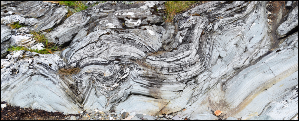
Arran’s oldest rocks, seen here near Lochranza. These were deformed and folded by tectonic processes deep in the Earth during the ‘Caledonian Orogeny’.

444
Silurian
419
Devonian
Old Red Continent
Arran was located in the middle of the ‘Old Red’ continent – we call the rocks of this period Old Red Sandstones. The great Caledonian mountain range was eroded by flash floods and large river systems which deposited huge amounts of gravel and sand onto the nearby desert plain.
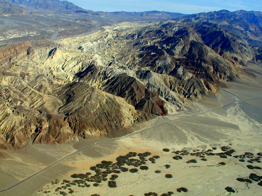
Arran’s landscape may have looked similar to the arid, bare slopes of Death Valley, USA. Photo credit: US National Archives.

359
Carboniferous
Tropical Arran
Arran’s location on the equator meant a lush, tropical climate. Forests of ancient trees supported invertebrates such as the giant millipede Arthropleura – the largest invertebrate ever to have lived on land.
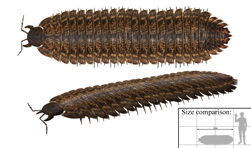
Giant arthropods roamed the land! See the famous tracks of the Arthropleura at Laggan Harbour, north Arran. Image credit: Tim Bertelink.
Coastal areas dominated by beaches and deltas were periodically drowned by a shallow sea due to fluctuating sea levels. The sea held an array of life including corals, crinoids, brachiopods, and bivalves.
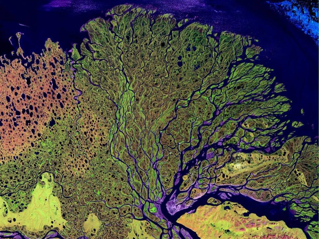
A false-colour satellite image of the Lena River Delta, Siberia. The image covers an area of approx. 100km across. Image credit: NASA.

299
Permian
Desert Storms
The continents merged into the ‘supercontinent’ called Pangea, with Arran situated in its centre at a similar latitude to that of the Sahara Desert today. The climate was hot and dry with few signs of life preserved in the rock record. Sand was whipped up by the wind into huge dunes while storms and flash floods raged across the landscape.

The ‘fossilised’ desert sand dunes on the north coast of Arran show spectacular cross bedding. They are red in colour due to an iron oxide (haematite) coating on the grains.

252
Triassic
Lakes and Lagoons
The supercontinent Pangea has begun to break apart, and arid conditions remained. Fine sand and clay were deposited in lakes and lagoons which were often dried out, creating mud cracks which are still visible today.
Traces of a giant reptile that roamed the sandy shores are preserved in Triassic sandstone on Arran. These remarkable Chirotherium ‘trace fossil’ footprints are thought to have been left by a large reptile which may have looked similar to a modern-day Komodo Dragon.
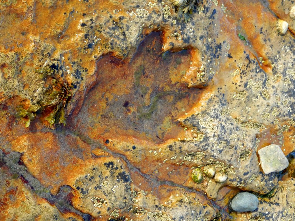
Huge reptiles walked over Arran! This is one of many Chirotherium trace fossils found on the island. This one can be found near to Kildonan. Image credit: (c) Karen Scott.

This sculpture in Hildburghausen, Germany is an artist’s impression of the beast. Image credit: Metilsteiner.

201
Jurassic
145
Cretaceous
66
Palaeogene
Fiery Arran
Scotland and North America were slowly ripped apart as the northern Atlantic Ocean began to form. The crust stretched, thinned and fractured, allowing a path for magma to reach the surface. Arran would have resembled the volcanic landscape of Iceland (below). The hills around Ard Bheinn in the centre of Arran are the site of a volcano which has been eroded down to its roots.

Arran in the Palaeogene! The eruption of Bárðarbunga Volcano, Iceland in 2014. Image credit: Peter Hartree.
During the Palaeogene, magma intruded horizontally between layers of much older rock, cooling to form the ‘sills’ of Drumadoon and the island of Pladda. Magma also flowed up through cracks and cooled, forming vertical ‘dykes’, like those in Kildonan and along the nearby coastline.

World-class examples of dykes and sills are found on the coastline west of Kildonan, looking towards the island of Pladda.
Arran’s majestic mountains in the north of the island were formed during this period too. They are made of granite – a coarse crystalline rock – formed deep within the Earth when molten magma rises, cools and solidifies.
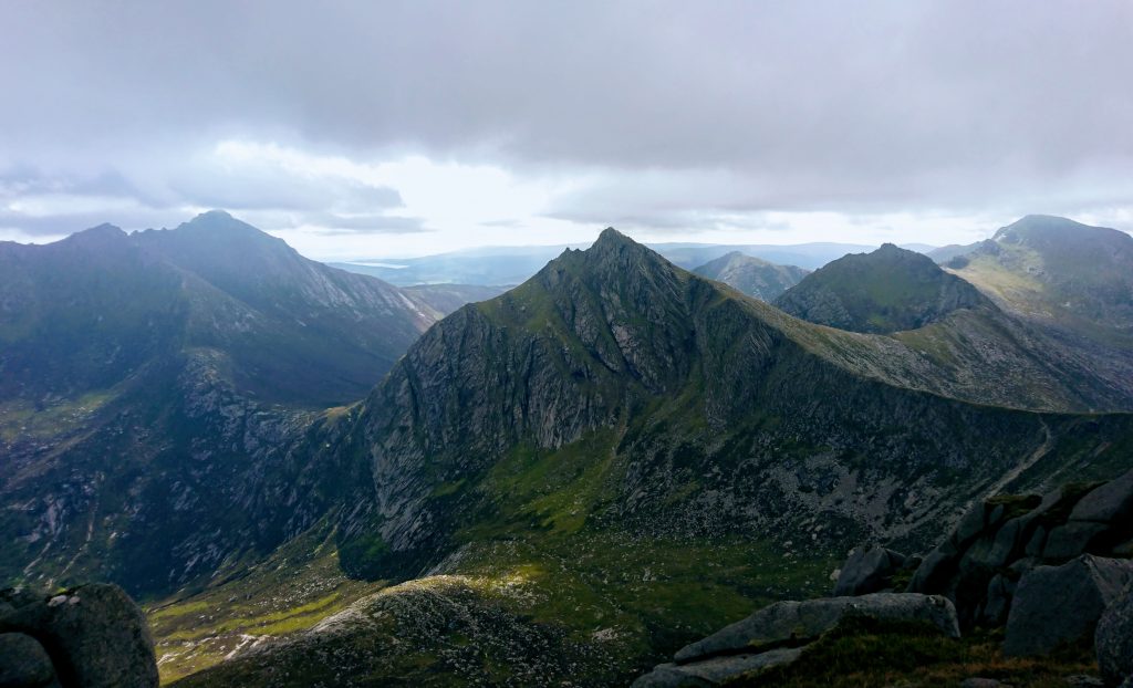
Arran’s dramatic granite mountains. The view from Caisteal Abhail facing south across Coire na h-Uaimh towards Cir Mhòr.

23
Neogene
2.6
Quaternary
The Power of Ice
Two and a half million years ago the Earth’s tectonic plates were in a similar position to where they are today. During the Quaternary period we have evidence that the global climate alternated between cooler (glacial) lasting around 100,000 years and warmer (interglacial) periods of around 10,000 years. During glacial periods Arran was covered in thick ice; glaciers eroded and sculpted the rocks beneath into the dramatic landscape you see today.
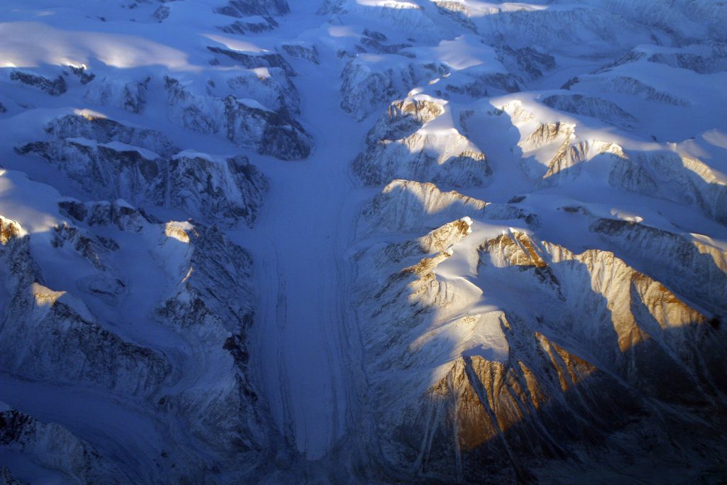
Modern day glaciers on the west coast of Greenland. Image credit: Doc Searls.
Glaciers cause erosion by stripping rocks and boulders from the
mountains, and using them like sandpaper to scour out the corries and
valleys, leaving behind distinctive mountain features like arêtes and pyramidal peaks. When the ice melts, all of the sand, gravel, and boulders are dumped. This sediment is known as glacial till, and covers much of Arran’s lowlands.
We can learn about Arran’s glaciers from the sediments they left behind. The lower part of this bank was deposited by streams of meltwater carrying sand and rock eroded by the Glen Catacol glacier.
The great weight of the thick ice sheet actually pushed down the land surface. When the ice melted and its weight was removed from the land, Arran began to rise up or ‘rebound’. As a result, many raised beaches (also known as ‘fossil shorelines’) were created, and these are easy to identify around the island today.
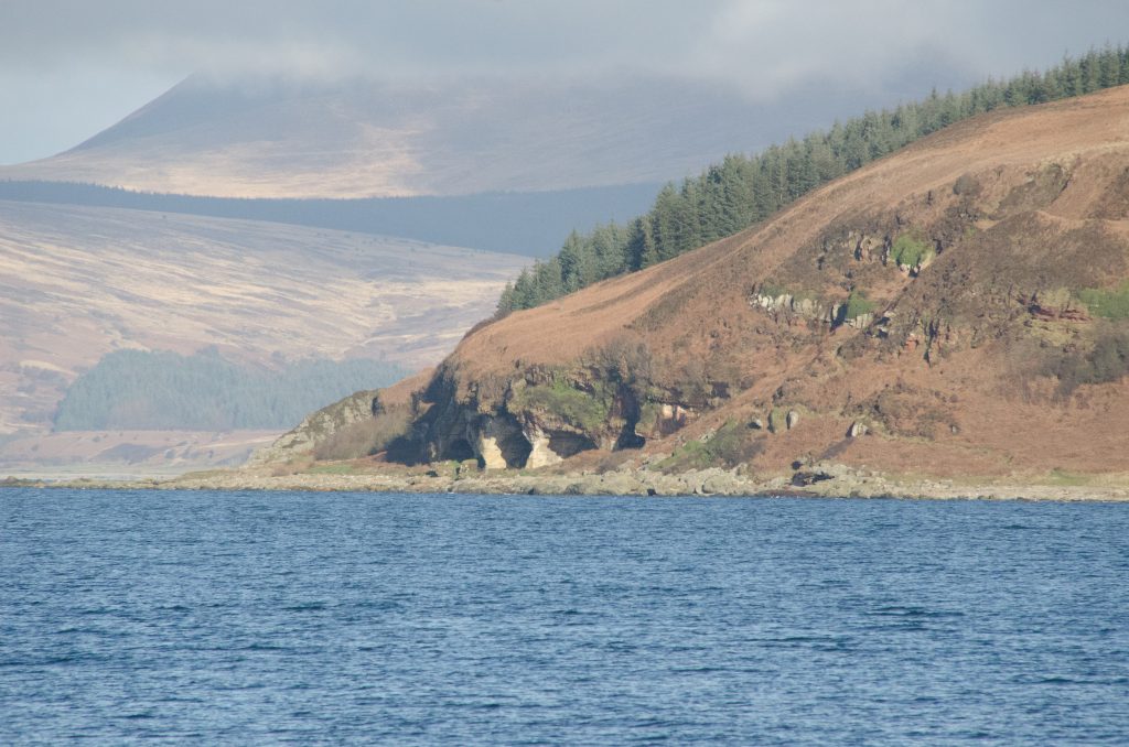
King’s Cave is formed of Permian sandstones eroded by the sea thousands of years ago when the relative sea level was much higher.
Further information:
- Visit one of our interpretation centres, follow one of our geotrails, or join us on a guided walk!
- Arran, Landscapes in Stone, written by Alan McKirdy, is a great place to begin to understand Arran’s landscape and its geology. Buy using this link to help support local bookshops – Arran Geopark will be given 10% too.
- Arran and the Clyde Island, A Landscape Fashioned by Geology, is a booklet available to download for free from the Scottish Geology Trust; part series produced by SNH and BGS covering all of Scotland.
- The Geological Society of Glasgow provides detailed and informative “excursion itineraries” to three locations: Corrie Shore, Drumadoon, and Lochranza. These are free to download and are updated chapters from the now out-of-print MacGregor’s Excursion Guide to the Geology of Arran (ISBN: 090289207X).
- The British Geological Survey’s “Special Sheet” S21 & S13 provides the definitive record of the island’s bedrock i.e. “solid” geology – and it looks great on the wall! (ISBN: 0751810401)
- The British Geological Survey’s Geology Viewer provides a free, online, interactive map of the UK’s geology.