


For the last 2.6 million years, ice sheets and glaciers have been repeatedly growing and melting on Arran as the ice ages come and go. Glaciers – rivers of ice that flow slowly downhill – are incredibly powerful erosional forces. The ice melted around 10,000 years ago, but has had a lasting impact on the island’s scenery. Almost all of the landscape features you can see on Arran have been shaped in some way by ice.
This time of the ice ages is the most recent geological period (see our Geological Timeline to put this in context), and is named the Quaternary. It is characterised by long glacial periods and shorter interglacials, and sculpted the landscape we see today. It was ice that carved out our iconic glens and shaped our spectacular mountains. The Caledonian Mountains were once Himalayan in scale, but millions of years of erosion have given us the landscapes we live in now.
Mountains
The northern, mountainous part of Arran is made up of an igneous rock called granite. This granite formed 60 million years ago as magma cooled deep below the Earth’s surface. Granite is a very hard rock that withstands the erosional power of glaciation relatively well, allowing it to stand proud against the surrounding landscape. As the softer rocks were worn down by the ice ages, the granite of northern Arran remains, forming the highest mountains for miles around. The name ‘Arran’ itself is thought to derive from the ancient Brythonic ‘high place’.
Granite is a coarse-grained rock, meaning you can see its crystals with the naked eye. Look for white feldspar, glassy grey quartz, and sparkly black biotite.
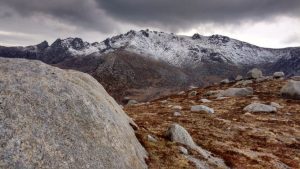
At the height of the last ice age, 20,000 years ago, Arran would have looked like Antarctica today: only the peaks of the highest mountains would have protruded above the ice. These exposed hilltops, sticking out above ice, are called ‘nunataks’, and are completely unprotected against the fierce effects of weathering. Physical weathering in the form of freeze-thaw occurs, where water collects in any joints or cracks in a rock, then freezes and expands; this process repeats itself, exploiting the weakness in the rock, until eventually the rock shatters. During the last glacial period on Arran, everything below 600m was covered in ice, with the rest poking out above. The result, when you look at the hills today, is that those higher than 600m are dramatically jagged-looking, with weathered tors and rocky pinnacles, whilst those lower than 600m are rolling, rounded hills which were smoothed out by the glaciers which flowed across them.
Glaciers create some specific landforms of their own, and these are well-represented on Arran! There is the pyramidal peak of Cir Mhòr, a spectacular, Matterhorn-style summit which is the result of three glaciers eroding back-to-back. There are many corries, which are bowl-shaped hollows formed as snow accumulates in a depression, compacts into glacier ice, and moves under its own weight to significantly deepen and widen the original depression. The knife-edge ridge known as the ‘Sleeping Warrior’ is an excellent example of an arête, formed between two parallel glacial valleys.

Hunter’s Ridge, leading up towards the pyramidal peak of Cir Mhòr. Landscapes like this attract huge numbers of walkers and climbers.
As well as being one of the island’s biggest tourist attractions, the mountains are also home to some of Arran’s most impressive wildlife. Remote granite crags above wide, open glens are the perfect nesting site for the island’s golden eagle population. With a wingspan of over two metres, the golden eagle is one of Britain’s largest birds!
Glens
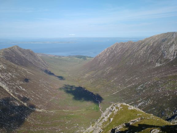
The north of the island contains many large, very deep glens, with flat valley floors and steep sides. These valleys formed when large glaciers – originating in the mountains – flowed downhill, ploughing their way through the landscape as they went. Protruding shoulders of hills were cut straight through, leaving ‘truncated spurs’ behind, and mountain streams which would have made their way gently down towards sea level were interrupted mid-flow, and forced to descend the new, vertical valley wall as a waterfall. Where a river will naturally meander its way through the landscape in an ever-changing series of twists and turns, a glacier decisively bulldozes its way directly through the land.
For this reason, the glacial valley of Glen Rosa is interesting, because rather than following a straight line, it has a definite bend in it. This change in direction of the glen represents the changing geology of the area – the intense hardness of the rock forced the glacier to change its course. It takes a lot to make a glacier change direction! A geological map of Arran shows that this bend coincides with a ‘baked margin’, a section of rock bordering an igneous intrusion which was literally ‘baked’ by the heat of magma pushing up beside it. And this baked rock is a force to be reckoned with for a glacier! So, the geology and the action of ice combine to create the landscape of Arran today.

Gleann Easan Biorach, a hanging valley in the north of the island, the name of which translates from Gaelic as ‘Glen of the Sharp Waterfalls’.
Glen Easan is a prime example of a hanging valley, another typical feature of a glaciated landscape. Located in the island’s north end, Glen Easan feeds down into the larger valley of Glen Chalmadale. The glacier which gouged out Glen Chalmadale was larger and more powerful than the one which created Glen Easan, and therefore was able to carve out a deeper valley. As a result, the smaller Glen Easan is left ‘hanging’ above Glen Chalmadale, with the River Easan tumbling down to meet the River Chalmadale in the main valley below. The Easan’s cascading waters were chosen by the Lochranza Distillery in the production of its whisky for providing the purest water on the island!
Glen Sannox, a U-shaped valley, with Sannox Burn running along its base. This burn is far too small to have carved out the huge glen on its own, and is thus an example of a ‘misfit stream’.
This burn is far too small to have carved out the huge glen on its own, and is thus an example of a ‘misfit stream’.Glacial valleys are not confined to the land; the Firth of Clyde is another glacially-carved trough, and contains some of the deepest coastal waters in the British Isles. It was formed by the same processes as the U-shaped glens on Arran, only to be infilled by the sea when ice sheets melted, meaning it can be described as a fjord.
Erosion and Deposition
Glaciers erode the landscape by stripping rocks and boulders from the mountains, and using them like sandpaper to scour out the corries and valleys. When the ice melts, all of the sand, gravel, and boulders are dumped. This sediment is known as glacial till, and covers much of Arran’s lowlands.
In our glens, this glacial till can be identified as moraine, deposited in a long strip of angular, unsorted material of all shapes and sizes. You might find this as a long bank of material stretching right across the glen (this is likely either terminal or recessional moraine), or you might find exposed sections of it stacked up against the valley walls (lateral moraine). Huge granite boulders that were plucked from the igneous mountains and dumped by glaciers on sedimentary rock in the island’s lowlands are called ‘erratics’.
Where a glen meets the sea, an outwash plain may be found. This is created as the glaciers melt – so, the ones visible on Arran today likely formed between 11,000 and 8,000 years ago. The melted ice washes out towards the sea, carrying with it increasingly fine sediment, which it deposits on its way. This finer sediment accumulates to form a wide, flat, fertile expanse of land at the mouth of the glen. This coarse, sharp sand was quarried and exported for use in water filtration, putting Arran in the unusual position of being able to quite literally sell sand to Saudi Arabia!
Kettle hole lakes can be found in outwash plains. These are formed when a block of ice detaches from the main glacier then is buried by outwash sediment as the glacier melts. Eventually, the block of ice melts, leaving a depression in the ground, as is found in Lochranza at Loch a’ Mhuilinn.

Looking down at Loch a’ Mhuilinn, a kettle hole lake in Lochranza, which today hosts an impressive dragonfly population.
Further information:
Land of Mountain and Flood by Alan McKirdy, John Gordon and Roger Crofts, published in 2017, is an excellent introduction to the formation of Scotland’s landscapes. Hostile Habitats: Scotland’s Mountain Environment by the Scottish Mountaineering Trust, published in 2019, covers the natural history of the nation’s hills, written from a hill-walker’s perspective. Buy using these links to help support local bookshops – Arran Geopark will be given 10% too.
If you want to explore Arran’s mountains for yourself, you should take a look at the Arran Mountain Festival! Held annually, the Mountain Festival hosts guided walks at a range of levels through Arran’s glens, over its ice-rounded hills, along its arêtes and up onto its pyramidal peaks – and Arran Geopark joins forces with the Festival to lead a geology-themed walk too!
Don’t visit Arran’s hills and wild coastline without an Ordnance Survey map! The whole island fits satisfyingly on to one sheet of an OS Landranger map: buy one here. Or for even more detail purchase an OS Explorer map. Buy using these links to help support local bookshops – Arran Geopark will be given 10% too.